관광산업의 최신 트렌드와 심층적인 인사이트를 제공하여 성공적인 비즈니스와 여행 경험을 선도합니다.
7am - 10am
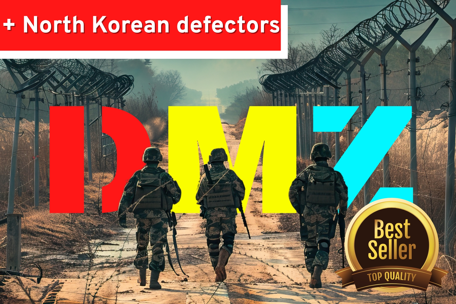
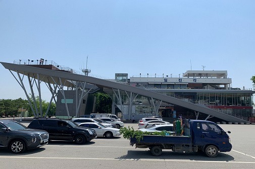
남한에서 일반인이 갈 수 있는 북한과 가장 가까운 곳, 임진각
임진각은 북한 실향민을 위해 1972년에 1번 국도를 따라 민간인이 갈 수 있는 가장 끝 지점에 세워졌다. 이후 다양한 시설들이 속속 들어서며 현재의 모습을 갖추게 되었고, 지금은 이 지역을 임진각 관광단지로 조성하여 경기관광공사가 관리하고 있다. 임진각 건물 3층에서는 임진강 자유의다리 일대의 아름다운 경관을 볼 수 있으며, 1층에서는 DMZ 특산품 및 다양한 기념품을 구매할 수 있다. 임진각 관광단지는 1950년 6월 25일 발발한 한국전쟁과 그 이후의 민족대립으로 인한 슬픔이 아로 새겨져 있는 곳. 임진강 지구 전적비, 미국군 참전비 등 각종 전적비가 있으며, 남북 분단 전 신의주까지 달리던 기관차가 전시되어 있다. 이 기관차는 한국전쟁 중 피폭된 후 반세기 넘게 비무장 지대에 방치되어 있던 열차로, 기관차에 있는 1,020여개의 총탄자국과 휘어진 바퀴는 참혹했던 당시 상황을 말해준다. 내부에 위치한 경기평화센터에는 북한의 생활필수품과 사진들이 전시되어 있고, 2층에서는 북한의 실생활을 보여주는 비디오를 상영한다.
옥상에는 임진강과 자유의 다리를 전체적으로 조망하는 전망대가 있고, 유료로 사용가능한 쌍안경이 있다. 임진각에서는 북한이 거의 보이지 않고 산 위주로 보인다. 맑은 날에는 전망대에서 망원경으로 개성을 볼 수 있다.
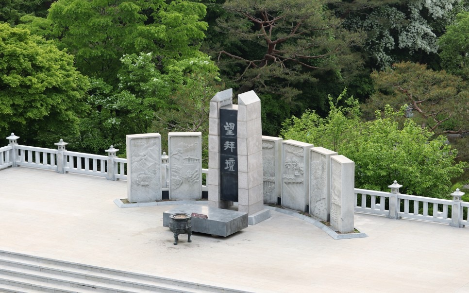
북쪽에 있는 가족을 그리워하는 마음을 가득 담아, 망배단
본관 건너편으로 이동하면 1985년 조성된 망배단이 있다. 망배단은 통일에 대한 염원과 북쪽에 남은 조상, 가족에 대한 명복과 그리움을 비는 탑이다. 한국전쟁시 자유를 찾아 남하한 5백만 실향민들의 슬픔을 고스란히 느낄 수 있는 곳. 추석이 되면 향로에 초가 태워지고 제사가 열린다. 탑을 둘러싼 7개의 화강석병풍에는 북한의 5개 도청을 형상화한 조각에 새겨져있는데 하나하나 살펴보면 그림처럼 아름답다.
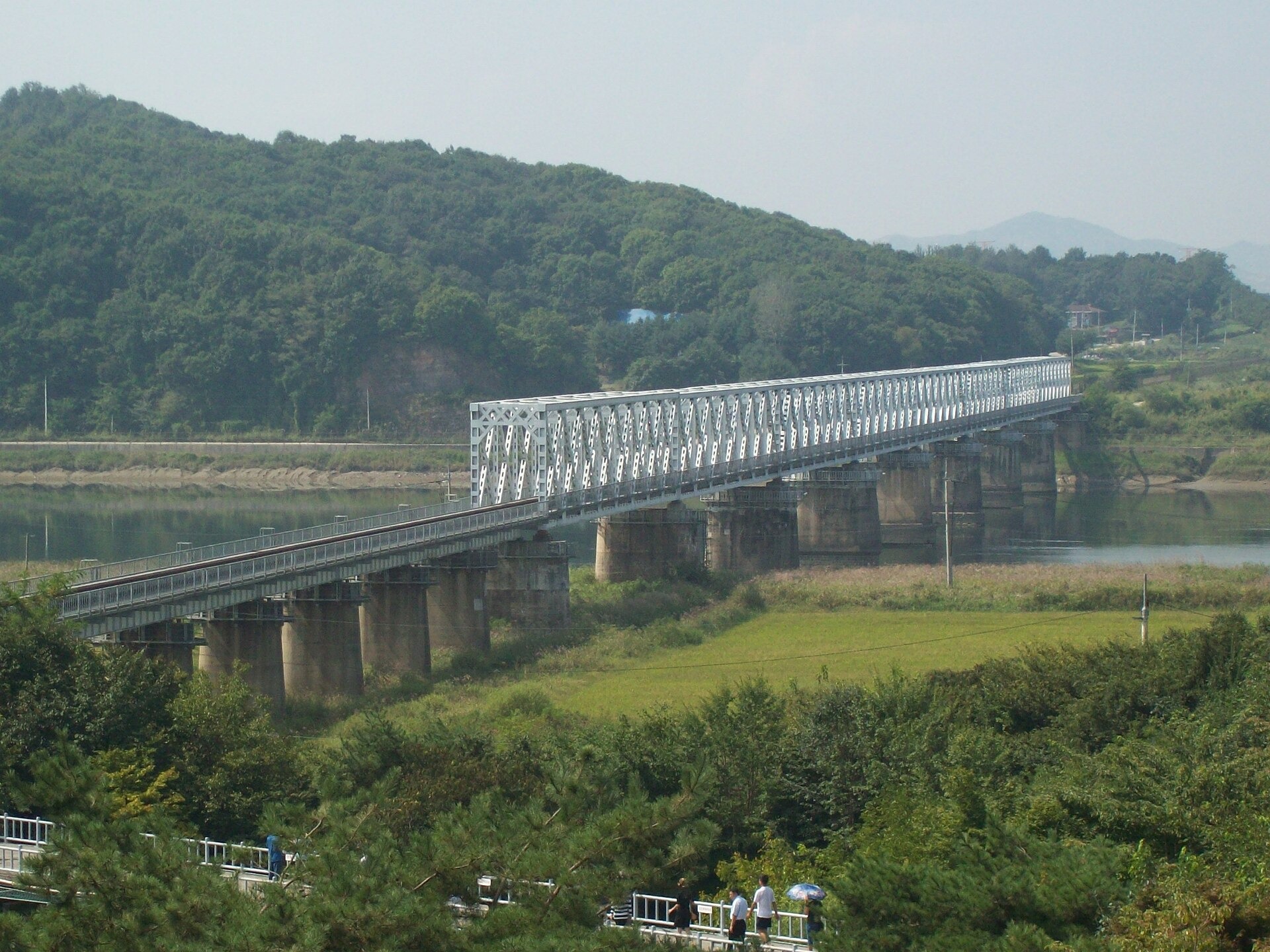
유엔군 반격으로 남한을 되찾은, 자유의 다리
임진각을 둘러봤으면 다음은 자유의 다리로 이동한다. 임진강의 남쪽과 북쪽을 잇는 다리로, 원래 철교였던 것을 도로교로 개조했다. 상행선은 한국전쟁 때 파괴됐다. 전쟁 초에는 북한군이 탈취했고 중간에 유엔군의 반격으로 되찾았으며, 이때 군인들이 '자유의 다리'라고 불렀다고 해 그대로 이름이 되었다. 휴전 협정 후에는 북한의 포로군들과 유엔군이 1만명 넘게 이 다리로 남한에 돌아왔다. 판문점에 위치한 돌아오지 않는 다리와 함께 한국전쟁의 생생한 비극을 보여준다.
10am-1pm
셔틀버스 탑승 후 임진각에서 D.M.Z로 이동합니다.
D.M.Z에서 보내는 시간은 약 세시간입니다.
전쟁없는 중간경계선, 비무장지대(D.M.Z)
북한이 남한을 해방시켜 통일을 성취한다는 명분으로 발발한 1950년 6월 25일 한국전쟁. 1951년 6월 30일 유엔군 총사령관이 공산군 측에 정전회담을 제의하면서 새로운 국면을 맞이했고, 회담 결렬과 재개를 반복한 끝에 1953년 7월 27일 유엔군 대표와 북한・중국 대표 간에 정전협정이체결되면서 남과 북 사이를 가로지르는 D.M.Z가 만들어졌다.
D.M.Z(Demilitarized Zone, 비무장지대)는 한국전쟁 휴전 협정 당시, 남·북한이 휴전선으로부터 남, 북으로 각각 2km씩 병력을 배치하지 않기로 협의한 특수지역이다. 비무장지대 없이 양쪽이 완전히 맞닿아 있다면, 군사적 충돌이 발생할 가능성이 높아지기에 비무장지대의 역할은 실질적으로도, 상장적으로도 매우 중요하다. 민간인이 허락없이 출입할 수 없으며 중립국 감시단이 지속적으로 감시하는 곳이기도 하다. 제3터널, 도라전망대, 통일촌을 둘러보는 코스를 포함하며, 임진각에서 셔틀버스를 타고 출발한다.
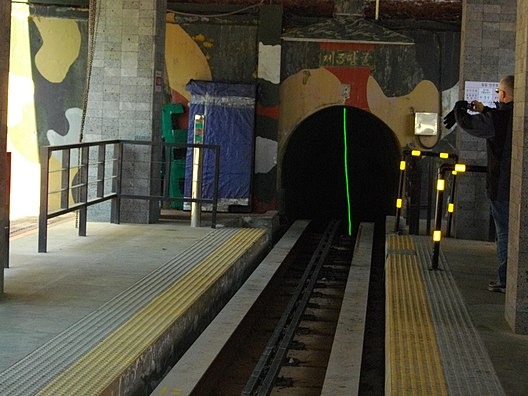
제3땅굴
북한이 대한민국 침략을 목적으로 건설한 군사용 터널이 존재한다는 것을 듣는 여행자들의 표정에는 놀라움이 떠오른다. 남침용 땅굴은 1997년 미국 해병대가 발간한 <북한 핸드북>에 따르면 약 20개로 추정되는데, 올해까지 발견된 땅굴은 네 개다. 1땅굴은 1974년 경기도에서 발견됐고, 수색중 총격전이 있었다. 2땅굴은 강원도에서 발견됐다. 폭음을 들은 군인들의 수색이 시작됐는데, 이때 폭탄을 건드려 총 8명의 군인이 전사했다. 유일하게 일반인에게 공개된 3땅굴은 1974년 측량기사 출신 귀순자가 제보해서 발견됐다. DMZ투어를 통해 땅굴을 둘러볼 수 있는데, 서울에서 고작 44km 떨어져있고 한번에 3만여명의 무장병력을 이동시킬 수 있다는 점에서 전쟁의 공포를 상기시킨다. 4땅굴은 1990년 강원도 해변가에서 발견됐다. 이때군견 헌트(hunt)가 폭발물 탐지 중 지뢰를 밟고 폭사해 땅굴 옆에는 헌트의 동상이 세워져있다.
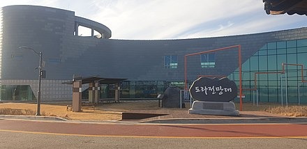
도라전망대
제 3땅굴 바로 옆에 있는 전망대로 1986년 국방부가 설치한 관광지로, 1987년부터 일반인에게 개방됐다. 500석 관람석과 VIP실, 상황실, 망원경 수십대가 설치되어 있는데 개성공단과 개성시변두리까지 또렷하게 보이는 위치다. 북한을 가장 자세하게 볼 수 있는 위치라 외국인들이 꼭 들러보고 싶어하는 곳.
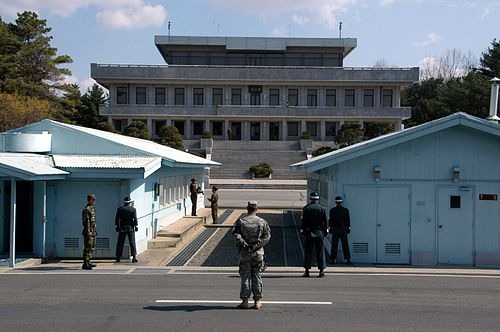
공동경비구역 J.S.A.
1953년 10월, 군사분계선을 중심으로 유엔군 측과 공산군 측의 공동경비구역 설정이 협의됐다. 이때 장방형(동서 800m, 남북 400m)의 공동경비구역이 만들어졌다. 초기에는 유엔군 측과 공산군 측이 경비와 관리를 공동으로 담당하는 말 그대로의 ‘공동경비구역’이었으나, 1976년 8월 18일 판문점 도끼 만행 사건 이후 군사분계선을 경계로 이남 지역은 유엔군 측이, 이북 지역은 공산군 측이 분리 경비하게 됐다. 2018년 9월 평양 남북정상회담에서 판문점 공동경비구역 비무장화 및 자유왕래에 합의했고, 이에 따라 JSA 감시초소 및 각종 화기가 상호 검증 아래 철수되어 비무장화 조치가 완료됐다. 지난해(2023년), 미국인 군인 트래비스 킹의 월북사건 이후 일반인 방문이 잠정 중지됐다. 2024년 2월 기준 일반인 방문이 불가해 많은 사람들이 재허가가 나기를 기다리고 있다.
서울렌즈는 단순한 한국명소가 아닌 근현대 역사적관점, 미식가의 관점 등 여행자의 시선에 맞춰 디테일하게 각색한 컨텐츠를 소개합니다. 남들이 다 아는 흔한 관광지가 아니라 서울렌즈에서 찾아낸 서울의 숨은 스팟을 만나보고 싶다면, 하이엔드 컨시어지 서비스를 제공하는 코스모진을 통해 여행을 문의하세요.
- Article in English
-
Imjingak
Imjingak was established in 1972 as the closest point civilians can access to North Korea along the 1st National Highway, for the South Korean refugees who fled from North Korea. Founded by Haitai Confectionery, it doesn't require complex approval processes like the Joint Security Area (JSA), making it a popular destination for both foreigners and locals alike. Inside the Gyeonggi Peace Center, North Korean essential items and photographs are exhibited, while videos depicting North Korean daily life are screened on the second floor.
On the rooftop, there is an observatory offering a panoramic view of the Imjin River and the Bridge of Freedom, along with binoculars available for use at a fee. From Imjingak, North Korea is scarcely visible, with the focus being primarily on the mountains. On clear days, visitors can use telescopes to observe Kaesong from the observatory.Mangbaedan
Located across from the main building, Mangbaedan was built in 1985. It is a tower that symbolizes the longing for reunification, as well as mourning and longing for ancestors and family members who remain in the North. It is a place where one can keenly feel the sadness of the five million South Korean refugees who sought freedom during the Korean War. During Chuseok (Korean Thanksgiving), incense is burned, and memorial services are held. The seven granite screens surrounding the tower are engraved with sculptures depicting the five provincial capitals of North Korea, each intricately beautiful.Bridge of Freedom
After exploring Imjingak, visitors move on to the Bridge of Freedom. This bridge connects the south and north sides of the Imjin River and was originally a railway bridge converted into a roadway. The northbound lane was destroyed during the Korean War. In the early stages of the war, it was captured by the North Korean army, but was later recaptured by the UN forces in a counterattack, hence the name "Bridge of Freedom" given by the soldiers. After the armistice agreement, more than 10,000 North Korean and UN soldiers returned to South Korea via this bridge. Together with the Bridge of No Return located at the Panmunjom, it vividly portrays the tragedies of the Korean War.D.M.Z.
The Korean War broke out on June 25, 1950, with North Korea's aim to liberate South Korea and achieve unification. On June 30, 1951, as the UN commander proposed ceasefire talks to the communist side, a new phase began. After repeated breakdowns and resumptions of talks, the armistice agreement was finally signed on July 27, 1953, between the UN representatives and those of North Korea and China, leading to the establishment of the DMZ (Demilitarized Zone) between the South and the North.
The DMZ, agreed upon during the Korean War armistice negotiations, is a special area where both South and North Korea agreed not to deploy troops within 2 km from each side of the ceasefire line. As an area without armament, its role is crucial both practically and symbolically. Civilians cannot enter without permission, and it is continuously monitored by neutral countries. It includes courses to visit the 3rd Tunnel, Dorasan Observatory, and the Unification Village, with shuttle buses departing from Imjingak.
The Third Tunnel
Discovered in 1978, the Third Tunnel of Aggression was found near the area of Namsan in South Korea. The expressions of travelers upon hearing about the existence of this tunnel reflect their astonishment, as it was constructed by North Korea with the purpose of invading South Korea. According to thepublished by the U.S. Marines in 1997, it is estimated that there are about 20 such tunnels, but only four have been discovered so far. The First Tunnel was found in Gyeonggi Province in 1974, where a skirmish ensued during the exploration. The Second Tunnel was discovered in Gangwon Province, where the search began after hearing the sound of digging. During the search, a booby-trapped bomb was accidentally detonated, resulting in the deaths of eight soldiers. The only tunnel open to the public, the Third Tunnel, was discovered in 1974 by a defected former surveyor. Visitors can explore the tunnel through DMZ tours, which serves as a stark reminder of the horrors of war, being just 44 km away from Seoul and having the potential to transport over 30,000 armed forces at once. The Fourth Tunnel was found in 1990 on the coast of Gangwon Province, and a statue of a military dog stands next to it, commemorating its sacrifice as it detonated a mine while detecting explosives during the hunt.
Dora Observatory
Situated right next to the Third Tunnel, Dorasan Observatory is a tourist destination installed by the Ministry of National Defense in 1986, and it has been open to the public since 1987. With 500 seats in the observation area, as well as VIP rooms, situation rooms, and dozens of telescopes, it offers a clear view extending all the way to the Kaesong Industrial Complex and the northern border area. It is the prime location for the most detailed observation of North Korea, making it a must-visit destination for foreigners.
Joint Security Area (J.S.A.)
In October 1953, an agreement was reached to establish a Joint Security Area centered around the Military Demarcation Line between the UN forces and the communist forces. At that time, a rectangular area measuring 800 meters east to west and 400 meters north to south was created as the Joint Security Area. Initially, it was a literal "joint security area" where both UN and communist forces were responsible for surveillance and management. However, after the brutal incident known as the Axe Murder Incident at Panmunjom on August 18, 1976, the area south of the Military Demarcation Line came under the surveillance of the UN forces, while the area north of it was monitored by the communist forces.
In the September 2018 Inter-Korean Summit held in Pyongyang, an agreement was reached to demilitarize and allow free movement within the Joint Security Area at Panmunjom. As a result, under mutual verification, observation posts and various weapons were withdrawn, and demilitarization was completed. Since last year (2023), civilian visits have been temporarily suspended following the defection incident involving American soldier Travis King. As of February 2024, civilian visits are not permitted, and many people are waiting for reauthorization.
Seoul Lens offers meticulously curated content tailored to the perspectives of travelers, focusing not just on typical Korean landmarks but also on the historical and modern contexts, culinary experiences, and other unique aspects. If you're interested in discovering Seoul's hidden gems as uncovered by Seoul Lens—not just the common tourist spots—reach out to Cosmojin, which provides high-end concierge services, to inquire about your travel arrangements.